Provinces map of Brazil

Map of regions in Brazil
The actual dimensions of the Brazil map are 2000 X 1901 pixels, file size (in bytes) - 334388. You can open, print or download it by clicking on the map or via this link: Open the map of Brazil.

Other maps of Brazil

Map of cities and regions in Brazil

More to see in Brazil
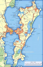
The Brazilian city of Maceio is quite a calm and safe place that is why so many Brazilians choose it as their vacation destination. Tourists and people from the continent come here to enjoy trouble-free recreation at the ocean coast, lie on the beaches under coconut palm trees, and walk on picturesque waterfronts that offer heartwarming views of the ocean. Maceio itself is a large port, so it is not rare to see numerous colorfully painted boats of local fishermen. Just like other resorts, this city has its own peculiarity and attraction – naturally formed pools that appear at the coast during the low tide. The area of the Brazilian megalopolis was discovered by European naval explorers in 1609. Having stepped on this land, Europeans quickly noticed that this region is perfectly suitable for agriculture. The first settlement on the site of modern Maceio appeared soon after the discovery. Slowly, immigrants from different European countries started settling in Brazil. They were exploring wild areas, building new fazendas, and making plantations. Year after year, the settlement was developing and expanding. The population of Maceio was increasing as well. Cultivating sugarcane became very popular in the region, and so big sugarcane plantations appeared near Maceio. Fruit …
Top extreme sights in Brazil

Rodovia da Morte

From the series “Most Dangerous and Lethal Roads”
The President Dutra Highway (BR-116) is one of the most dangerous and mortal roads in Brazil. To be more exact it is its section Curitiba-Sao Paolo that makes it so dangerous. BR-116 is the largest highway in the country, linking Porto Alegre and Rio de Janeiro and passing through a number of major cities as well as Curitiba and Sao Paulo. The area between these major cities is called Rodovia da Morte (Highway of Death), due to its many accidents.

The sad statistics no longer surprises the locals. They've already got accustomed to the daily accidents on the road. This section is really difficult so road fatalities are distressingly common.

A part of the route runs along the cliffs and the drivers have to pass through the numerous tunnels and narrow areas that lack any fences. … Read all

Rio carnaval

From the series “Most Enchanting and Vibrant Festivals”
The Carnival in Rio de Janeiro is a world famous and the most recognizable carnival in the world. The main city event begins on Friday before Ash Wednesday. Best samba schools in Brazil are involved in the preparation for the holiday. The exact origin of a fabulous holiday is unknown, according to some, the carnival was originally a Greek spring festival. The Romans adopted the same tradition.

In the Middle Ages the carnival was considered a holiday of the poor. Over and over again it was banned, but each time the locals managed to defend their right to a holiday. For hundreds of years the carnival has become a large-scale celebration. Preparations for the Rio Carnival go on for months before the event and hundreds of thousands of people are involved in the preparation. Despite the fact … Read all
All unique sightseeing Brazil
 

Cuisine and restaurants of Brazil

Secure Connection
Main Office
Weegschaalstraat 3, Eindhoven
5632 CW, The Netherlands
+31 40 40 150 44


Terms of Service | Privacy Policy | About us
Copyright © 2002 - OrangeSmile Tours B.V. | Incorporated by IVRA Holding B.V. - Registered in The Dutch Chamber of Commerce (Kamer van Koophandel KvK, The Netherlands) No. 17237018