Detailed hi-res maps of Dar es Salaam for download or print

Large map of Dar es Salaam 1
The actual dimensions of the Dar es Salaam map are 1530 X 1016 pixels, file size (in bytes) - 276168. You can open this downloadable and printable map of Dar es Salaam by clicking on the map itself or via this link: Open the map.
More to see in Dar es Salaam
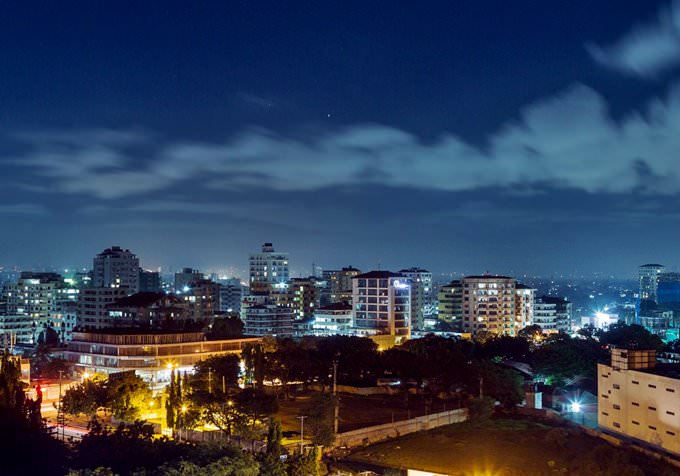
Dar es Salaam is one of the biggest cities in Tanzania. This is an important city on the Indian Ocean’s coast. Moreover, Dar es Salaam is a major port in Tanzania. Many tourists from other countries start their adventures in Tanzania exactly from this settlement. However, Dar es Salaam deserves more attention because the city has so much to offer. Beautiful beaches, marvelous and attractive architecture, and massive opportunities for active recreation make this city a destination that is worth exploring. Dar es Salaam is suitable not only for adult travelers and fans of extreme but also for families with small children. There was a village named Mzizima on the site of modern Dar es Salaam in the 19th century. Local people mostly did fishing for a living. The first European arrived in the region in 1859. This was Albert Roscher from Hamburg. Three years later, Sultan Sayyid Majid bin Said decided to build a city on the coast of the Indian Ocean. The sultan gave the new city that name that we all know today - Dar es Salaam. When Sayyid Majid bin Said died, the process of building the city slowed down. Only in 1889, when Germans occupied the city, the first dock appeared in Dar es Salaam. The British became rulers in the region in 1916. After the end of World War II, Dar es Salaam started developing actively. In winter 1961, Tanganyika finally became independent, and Dar es Salaam became its capital. When Tanganyika and the People’s Republic of Zanzibar merged … Read further

Our guide chapters over Dar es Salaam

Dar es Salaam sightseeing

After the end of World War II, Dar es Salaam started developing actively. In winter 1961, Tanganyika finally became independent, and Dar es Salaam became its capital. When Tanganyika and the People’s Republic of Zanzibar merged to form a new country, Tanzania, it was decided to make another city the new capital. The process of changing the capital hasn’t finished yet. The national university opened in … Open

Moving around in Tanzania - transportation

All major cities of the country are connected by railways. Their total length is about 4 000 kilometers. Trains vary in class. They have a first class, a sitting second class, a sleeping second class and a sitting third class. The first two classes of trains are characterized by minimal comfort options. Cars of the third class are not equipped with air conditioning and are always crowded. The price of the ticket is from 1 dollar to 5 dollars. The ticket allows you to cover a distance of up to 100 kilometers. Ferries regularly ply between the islands and the mainland of Tanzania. The vehicle can be either an old and rusty water transport or a relatively modern and comfortable ship. Therefore, the cost of tickets varies significantly. … Open

Detailed maps of neighbouring cities to Dar es Salaam

Secure Connection
Main Office
Weegschaalstraat 3, Eindhoven
5632 CW, The Netherlands
+31 40 40 150 44


Terms of Service | Privacy Policy | About us
Copyright © 2002 - OrangeSmile Tours B.V. | Incorporated by IVRA Holding B.V. - Registered in The Dutch Chamber of Commerce (Kamer van Koophandel KvK, The Netherlands) No. 17237018