Detailed hi-res maps of Charlotte Amalie for download or print

Large map of Charlotte Amalie 1
The actual dimensions of the Charlotte Amalie map are 1984 X 1445 pixels, file size (in bytes) - 420056. You can open this downloadable and printable map of Charlotte Amalie by clicking on the map itself or via this link: Open the map.
Detailed map of Charlotte Amalie 2
The actual dimensions of the Charlotte Amalie map are 1750 X 1148 pixels, file size (in bytes) - 348497. You can open, download and print this detailed map of Charlotte Amalie by clicking on the map itself or via this link: Open the map.
Large map of Charlotte Amalie 3
The actual dimensions of the Charlotte Amalie map are 1530 X 1013 pixels, file size (in bytes) - 184082. You can open this downloadable and printable map of Charlotte Amalie by clicking on the map itself or via this link: Open the map.
More to see in Charlotte Amalie
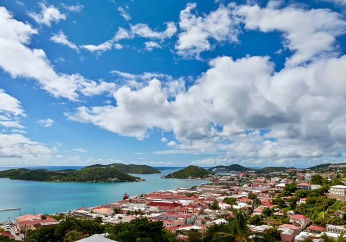
The Virgin Islands are a true gem of the Caribbean. The fabulous city of Charlotte Amalie is the main destination on the islands. This settlement is the capital of the U.S. Virgin Islands. The charming resort city is situated on the largest island of the group, Saint Thomas. Nowadays, Charlotte Amalie is a popular tourist destination that attracts guests from all over the world. Tourists from different countries arrive to sunbathe in the rays of the Caribbean sun, enjoy swimming in warm water, and admire the natural beauty of this region. The information about the first settlers on Saint Thomas dates back to the period when Christopher Columbus made his second journey. These were several American Indian tribes, such as the Taino, Arawaks, and Caribs. However, Charlotte Amalie started developing after the region had established business relations with Dutch colonies in the West Indies. Charlotte Amalie as a town has existed since 1671. This is when Dutch King Christian V made an order to found a new settlement. Initially, the city had another name – Taphus. This word means “beer house” in Dutch. Twenty years later, the city changed its name to Charlotte Amalie to honor Christian V’s wife. It was decided to build Fort Christian at the beginning of the 70s of the 17th century in the coastal part of the city in order to protect the haven from invaders. Cane sugar manufacture and slave trade were the main sources of income in the budget of the city. The 19th … Read further

Our guide chapters over Charlotte Amalie

Charlotte Amalie sightseeing

One of the most beautiful beach resorts on the islands is situated not far from the city. This is Magens Bay Beach, an incredibly beautiful bay covered with soft white sand. Tropical trees grow at the borders of the coastal area, separating the beach from the rest of the city. Volcanic rocks with the porous structure add a special charm to this enchanting area. Scattered in the territory of the beach, these rocks … Open

Detailed maps of neighbouring cities to Charlotte Amalie

Secure Connection
Main Office
Weegschaalstraat 3, Eindhoven
5632 CW, The Netherlands
+31 40 40 150 44


Terms of Service | Privacy Policy | About us
Copyright © 2002 - OrangeSmile Tours B.V. | Incorporated by IVRA Holding B.V. - Registered in The Dutch Chamber of Commerce (Kamer van Koophandel KvK, The Netherlands) No. 17237018