Detailed hi-res maps of Ponta Delgada for download or print

Large map of Ponta Delgada 1
The actual dimensions of the Ponta Delgada map are 4768 X 2520 pixels, file size (in bytes) - 1285589. You can open this downloadable and printable map of Ponta Delgada by clicking on the map itself or via this link: Open the map.
More to see in Ponta Delgada
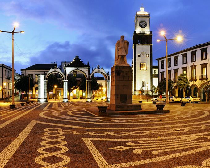
The enchanting city of Ponta Delgada is an amazing resort and the capital of the Autonomous Region of the Azores. The city has many luxurious villas and beautiful churches that have been here since Ponta Delgada was a large and important port. Having arrived in Ponta Delgada, tourists usually enjoy swimming in thermal springs and visiting volcanic lakes, many of which are formed in the craters. Caldeirro Volcano, which has been extinct for many centuries, is one of the biggest points of interest in the area. Local volcanic lakes have water of different colors ranging from blue to emerald green. Needless to say, there are always many vacationers who come to see the lakes and relax at their shores. A small village emerged on the site of the modern resort in 1449. Local people were mostly engaged in fishing. At that time, no one thought that the settlement would ever become the capital of the Azores. In 1546, a devastating earthquake happened in Sao Miguel. This disaster almost completely wiped the city off the face of the earth. This is how Ponta Delgada became the new capital of the island. The administration of Sao Miguel moved to the new location. As expected, Ponta Delgada started growing and developing rapidly. Its population was increasing fast too. To prevent pirate attacks and protect the territory of the city from the enemy invasions, several fortifications were built in Ponta Delgada in the sixteenth and seventeenth centuries. The 19th century was a true period … Read further

Our guide chapters over Ponta Delgada

Ponta Delgada sightseeing

Besides beach recreation, Ponta Delgada can offer its guests to visit several amazing natural attractions such as the Gruta do Carvao Caves. This is the longest naturally formed volcanic tunnel on the island. The length of the Gruta do Carvao Caves is one thousand ninety hundred and twelve meters. A transitional section, the length of which is seven hundred meters, is located between the caves. Scientists performed … Open

Moving around in Portugal - transportation

Trams and lifts are equally popular in Lisbon. There is a metro in the capital. At the moment, there are only four subways that connect the city center with the most significant areas. The country’s air transportation is also developed at a high level. There are several major international airports which operate in the country, but the internal displacement is poorly developed. The most popular flights are the ones which connects the mainland of Portugal with the island part of the country. … Open

Economy roadmap of Portugal

Tourism is an important activity in Portugal. Every year, more and more travelers come to the country. Consequently, high-class hotels and hostels are being built, and the service sector is developing. The transport system in the country is poorly developed. Today, there are only 35,000 kilometers of railways in the country, of which about 1,000 are electrified. The length of highways with a hard surface is about 60,000 kilometers. Sea transport is mostly used for transportation to the mainland from the island. However, the tonnage of the marine fleet does not exceed 1.2 million tons. … Open

Detailed maps of neighbouring cities to Ponta Delgada

Secure Connection
Main Office
Weegschaalstraat 3, Eindhoven
5632 CW, The Netherlands
+31 40 40 150 44


Terms of Service | Privacy Policy | About us
Copyright © 2002 - OrangeSmile Tours B.V. | Incorporated by IVRA Holding B.V. - Registered in The Dutch Chamber of Commerce (Kamer van Koophandel KvK, The Netherlands) No. 17237018