Detailed hi-res maps of Parga for download or print

Large map of Parga 1
The actual dimensions of the Parga map are 2881 X 2132 pixels, file size (in bytes) - 1474275. You can open this downloadable and printable map of Parga by clicking on the map itself or via this link: Open the map.
More to see in Parga
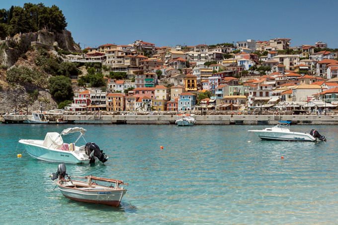
Parga is a picturesque resort town in Greece that is conveniently located between the two coastal cities, namely, Preveza and Igoumenitsa. Parga has an unusual shape that resembles an amphitheater. Visit this Greek resort to admire a striking combination of gorgeous rocks and crystal clear sea. Perhaps, Parga is the most unique resort in northwestern Greece. The historic heritage of the town is like a magnet for all curious tourists, and local hospitality together with mesmerizing views make Parga a dream destination. Besides cultural discoveries, the Greek resort can offer comfortable beaches that are great for family travel and groups of friends. Are you a fan of active recreation? You will always find an activity to fit your taste at the seaside. The first mentions of Parga date back to the 13th century. This is the time when the first settlement appeared on the Pezovolo Mountain. For many years, the settlement was living under a constant threat of an attack of the Albanian army. In 1360, local people came up with a plan on how to protect their homeland from alien attacks. They simply moved Parga to the place where the town is located nowadays. Neighbor Normans built the first fortress in the town. This stronghold was monitoring the area round the clock to prevent the rapid attacks of the enemies. At the end of the 18th century, when admiral Ushakov was making his Mediterranean campaign, the Russian Empire captured Parga. This town was the only free settlement in … Read further

Our guide chapters over Parga

Parga sightseeing

The most comfortable way to reach Parga is to fly to Corfu first. This Greek city has a large international airport that receives many flights from different countries every day. Upon your arrival in Corfu, take a ferry ride to Igoumenitsa. The ferries depart every hour and reach the final destination in one and a half hours. The distance between Igoumenitsa and Parga is roughly forty kilometers. It takes … Open

Moving around in Greece - transportation

Roads in major cities of Greece are average. At the same time, the quality of pavement is constantly improving. Many of the routes marked on the map as ground, have long been covered with a solid layer of asphalt. However, the statistics of road accidents is quite deplorable. The most common cause of catastrophes is overtaking, although in cities and the speed limit of 50 kilometers per hour is accepted. Motorcycles and mopeds are used too. At the same time, the behavior of drivers of two-wheeled vehicles is still less aggressive than in the countries of Asia. On some islands, for example, Kos or Fesalia, there are quite a few cyclists. It is worth noting that car drivers are respectful of them. A bicycle is not the best way to travel along the mainland Greece, as the terrain is very hilly. There are practically no dedicated bicycle lanes in the country. … Open

Detailed maps of neighbouring cities to Parga

Secure Connection
Main Office
Weegschaalstraat 3, Eindhoven
5632 CW, The Netherlands
+31 40 40 150 44


Terms of Service | Privacy Policy | About us
Copyright © 2002 - OrangeSmile Tours B.V. | Incorporated by IVRA Holding B.V. - Registered in The Dutch Chamber of Commerce (Kamer van Koophandel KvK, The Netherlands) No. 17237018