Map of cities in Egypt

Map of cities in Egypt
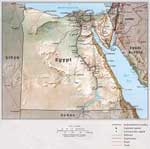
The actual dimensions of the Egypt map are 1084 X 1080 pixels, file size (in bytes) - 275762. You can open, print or download it by clicking on the map or via this link: Open the map of Egypt.

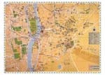
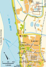
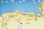
Additional maps of Egypt

Map of cities and regions in Egypt

More to see in Egypt
Luxor is a true treasure of Egypt. This ancient city is situated on the right bank of the Nile. Currently, this is a major center of archaeology. No other city in the world has so many landmarks of the ancient world as Luxor. That is why there is nothing strange in the fact that buses bring countless tourists from all Egyptian resorts to Luxor every year. This once again proves the status of the “treasure of the Nile”. Even scorching sun doesn’t stop tourists who are eager to see the beauty of this place and the remains of the ancient landmarks. It is incredible to see so many prehistoric attractions in one place. In the past, the ancient Egyptian city of Waset existed on the land of modern Luxor. The Greeks called this city Thebes or “the city of the 100 gates” because Luxor was standing on the former capital of the Ancient Egypt – Thebes. The history of the old capital started in the 3rd century BC. Luxor became a major settlement yet in more than 2,000 BC. This is the time when pharaohs from the 11th Dynasty ruled in Egypt. A major period of prosperity and development started for this city in the 16th century BC. When the Greek-Roman period started in the country and the capital was moved to Alexandria, Thebes didn’t lose its importance and remained one of …
Top sights in Egypt

6th October Bridge

From the series “The Longest Bridges in the World”
In Cairo is the bridge of 6 October with the length of 20.5 km. This bridge crosses the Nile twice and connects the western part of the city to the international airport, which is located in the eastern part of Cairo. The bridge was named to honor the important historical event. On 6 October 1973, the Ramadan war between Egypt and Israel began. The bridge building started in Cairo in 1969 and lasted a little over 30 years. In 1996 the bridge was put into operation.

Since the opening, the bridge of 6 October has been the most important street of the capital, but also of the whole state. Every day driving more than 500,000 people cross the bridge, which is also the number of guests from other countries. With care that traffic on the bridge is very dense at any time of the day, the trip … Read all

Suez Canal

From the series “Greatest Man-Made Waterways and Channels”
The most famous and recognizable one on the planet is the Suez Canal that connects the Red Sea to the Mediterranean Sea. The unique geographical location between Africa and Eurasia gives the canal the priority of being an important transport junction and one of the outstanding global sights. The canal is 163 km long and 60 metres wide, its depth is approximately 20 metres.

The passing vessels spend at least 14 hours to bridge the distance. About 50 units of water transport transit the waterway. The Suez Canal was opened for navigation in 1869. It has no shipping locks. The Canal is an important link between two major harbour cities of Suez and Said, which are also trading and travel centres of great importance. The idea of ​​establishing a grand canal dates back to the oldest times, … Read all
All unique sightseeing Egypt
 

Culture of regions in Egypt

Secure Connection
Main Office
Weegschaalstraat 3, Eindhoven
5632 CW, The Netherlands
+31 40 40 150 44


Terms of Service | Privacy Policy | About us
Copyright © 2002 - OrangeSmile Tours B.V. | Incorporated by IVRA Holding B.V. - Registered in The Dutch Chamber of Commerce (Kamer van Koophandel KvK, The Netherlands) No. 17237018