Detailed hi-res maps of Londonderry for download or print

Large map of Londonderry 1
The actual dimensions of the Londonderry map are 2500 X 3346 pixels, file size (in bytes) - 1963010. You can open this downloadable and printable map of Londonderry by clicking on the map itself or via this link: Open the map.
Detailed map of Londonderry 2
The actual dimensions of the Londonderry map are 2427 X 1944 pixels, file size (in bytes) - 1279574. You can open, download and print this detailed map of Londonderry by clicking on the map itself or via this link: Open the map.
Large map of Londonderry 3
The actual dimensions of the Londonderry map are 1000 X 997 pixels, file size (in bytes) - 157785. You can open this downloadable and printable map of Londonderry by clicking on the map itself or via this link: Open the map.
More to see in Londonderry
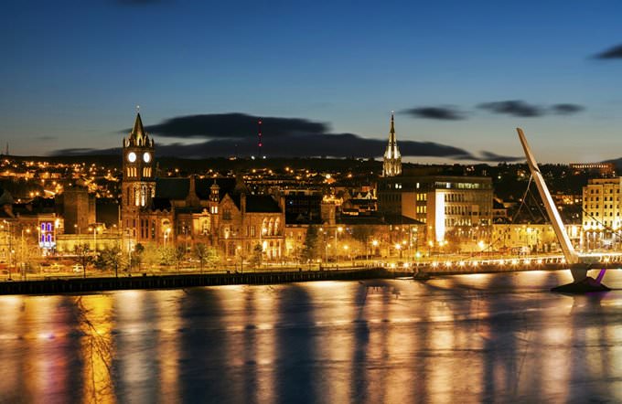
Londonderry is the second-largest city in Northern Ireland. This is also a large and important port. Local people love their homeland and usually informally call the city “Derry”. Tourists are always welcome in this part of the country. Derry gladly reveals its history and culture to guests of this charming region. Guests can learn more about the Siege of Derry, find out how local people survived in this tough period in the history of the city, and listen to many interesting details about the Battle of the Bogside. The city still has walls of the old fortress that dates back to the 17th century. Overall, Londonderry is a pleasant and hospitable city with friendly people, and this fact makes a stay here even more enjoyable. First mentions of Derry appeared in the 6th century. This is the time when St. Columba built the first monastery on the bank of the River Foyle. Starting from that moment and during the next five centuries, Derry was a monk settlement. In 1608, the Irish coastal city capitulated to Sir Cahir Rua O'Doherty, the ruler of Inishowen. He later burnt Derry and killed its governor. However, the rebellion was put down later. Starting from 1613, a massive reconstruction took place in Derry. The building works lasted six years. During the period of the Wars of the Three Kingdoms, the city suffered much damage and many of its people were killed. When World War I started, more than 5,000 men from Londonderry became soldiers and joined the British army. With … Read further

Our guide chapters over Londonderry

Londonderry sightseeing

Twenty years later, the tower became deteriorated and was at risk of falling. To prevent this, it was decided to remove the added part. The dilapidated part of the cathedral was rebuilt at the beginning of the 19th century. Another twenty years later, the cathedral finally got a spire. The portico in the southern part of the cathedral was removed, and the east tower was renewed. The cathedral’s inner decor … Open

Moving around in Great Britain - transportation

The United Kingdom of Great Britain has the excellent transport infrastructure. Not only the huge tourist flow, but also the development of the country itself and, in particular, the business sphere contributed there. The total length of all roads is at least 399 thousand kilometers. At the same time, there are relatively few highways in the country. They make only about three and a half thousand kilometers. You can travel by car in any region of the country. Don’t forget that the UK has the left-hand traffic. In London, there is a metro or a tube that embraces 12 underground, land and mixed lines. It is worth noting that the lines are often split into separate small branches, so you should always follow the transport route. … Open

Detailed maps of neighbouring cities to Londonderry

Secure Connection
Main Office
Weegschaalstraat 3, Eindhoven
5632 CW, The Netherlands
+31 40 40 150 44


Terms of Service | Privacy Policy | About us
Copyright © 2002 - OrangeSmile Tours B.V. | Incorporated by IVRA Holding B.V. - Registered in The Dutch Chamber of Commerce (Kamer van Koophandel KvK, The Netherlands) No. 17237018