Detailed hi-res maps of Echternach for download or print

Large map of Echternach 1
The actual dimensions of the Echternach map are 4134 X 2776 pixels, file size (in bytes) - 1756653. You can open this downloadable and printable map of Echternach by clicking on the map itself or via this link: Open the map.
More to see in Echternach
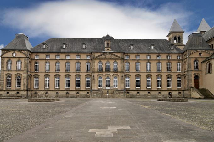
Echternach is the central settlement in the canton of Echternach in Luxembourg. This town is situated on the bank of the picturesque Sauer River. By the way, this river forms a natural border with Germany. The town is not big – its population is only around five thousand people. Nevertheless, Echternach greets thousands of tourists who come to this lovely settlement from different parts of the world every year. Echternach is a charming place that pleases its guests not only with beautiful nature but also with interesting landmarks. According to historical data, the first settlement in this area appeared yet during prehistoric times. During the Roman epoch, there was a big villa here. It belonged to a rich noble. Unfortunately, archaeologists still do not know anything about that person. At the end of the 7th century, the town and abbey appeared in the area thanks to the efforts of an Irish monk. A bit later, the first basilica was built here. In the 30s of the 13th century, Echternach officially became a town. Starting from that period, the settlement had to surround its territory with a wall, the total length of which was two kilometers. Several guardian towers appeared on the perimeter of the wall. The Town Hall building was erected not far from the basilica. The Town Hall has remained the main symbol of the town until modern times. Echternach got its “symbol” in the 30s of the 13th century. Almost one and a half century later, the abbot occupied the building, … Read further

Our guide chapters over Echternach

Echternach sightseeing

The Market Square is an important historical landmark in Echternach. This square was always crowded because numerous merchants were coming to sell their goods, jugglers performed in front of the public, and traveling musicians appeared from time to time to entertain locals with their marvelous shows. However, the Cross of Justice has always been the main symbol of the square. The name of the cross is not random. In … Open

Moving around in Luxemburg - transportation

The air transport network is also developed in the country. Luxembourg Findel Airport is located 5 kilometers east of the Capital. It is the main air harbor of the country. The airport makes more than 800 flights a week and connects Luxembourg with many European cities. In addition to buses, you can reach the airport by taxi, as well as by your car, which you can leave on any one of the four levels of underground parking. Also, taxis run all over the country. You can request for a taxi by calling the dispatcher, or by using special parking for taxis. The network of automobile roads with high-grade coverage is about thirty thousand kilometers. This includes even the most remote corners of Luxembourg. The cars used in Luxembourg are right hand driven, and the speed limit is 60 km/h in residential areas, 90 km/h outside them, and 120 km/h on the motorways. In Luxembourg, there is no direct access to the sea, but along the Moselle River there is a water connection with neighboring countries and the North Sea. Tourists also travel on the Sauer River for sightseeing. … Open

Economy roadmap of Luxemburg

Luxembourg despite its modest territorial size is considered a highly developed country and is included in the top rating of the richest countries in Europe. The main source of GDP comes from profits from the service, trade, and financial sectors. The financial well-being of the population is also due to the fact that more than half of all able-bodied citizens are engaged in the main sectors of the Luxembourg economy. In the middle of the last century, the most important branch of industry in Luxembourg was ferrous metallurgy. This was due to the discovery of many deposits containing huge reserves of iron ore. Based on this, the steel industry flourished. However, by the end of the last century this sector ceased to exist and the most recent blast furnace was shut down. … Open

Detailed maps of neighbouring cities to Echternach

Secure Connection
Main Office
Weegschaalstraat 3, Eindhoven
5632 CW, The Netherlands
+31 40 40 150 44


Terms of Service | Privacy Policy | About us
Copyright © 2002 - OrangeSmile Tours B.V. | Incorporated by IVRA Holding B.V. - Registered in The Dutch Chamber of Commerce (Kamer van Koophandel KvK, The Netherlands) No. 17237018