Detailed hi-res maps of Canterbury for download or print

Large map of Canterbury 1
The actual dimensions of the Canterbury map are 1530 X 1014 pixels, file size (in bytes) - 277933. You can open this downloadable and printable map of Canterbury by clicking on the map itself or via this link: Open the map.
Detailed map of Canterbury 2
The actual dimensions of the Canterbury map are 1100 X 776 pixels, file size (in bytes) - 269261. You can open, download and print this detailed map of Canterbury by clicking on the map itself or via this link: Open the map.
Large map of Canterbury 3
The actual dimensions of the Canterbury map are 1199 X 851 pixels, file size (in bytes) - 257675. You can open this downloadable and printable map of Canterbury by clicking on the map itself or via this link: Open the map.
More to see in Canterbury
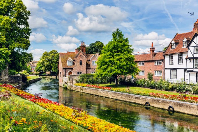
Canterbury is a British city in the county of Kent. The population of this city is only forty-five thousand people. The city is built on the River Stour that divides into two arms in the south-eastern part of Canterbury. One of these creeks flows along the fortress wall that now lies in ruins, and the other creek is like an arrow that pierces the city. Canterbury is conventionally divided into several parts, and this fact differs it from other cities in England. The central part of the city is the best place to learn more about the history of the region. North and West Canterbury are famous for their pubs and nightclubs, and the southern and eastern parts of the city are the location of shops and restaurants. The territory of modern Canterbury was inhabited yet during the prehistoric times. Archaeological excavations prove this fact. Scientists discovered tools that are typical for the Palaeolithic age, Stone Age items, and various artifacts that date back to the Bronze Age. First mentions of this region date back to the period when the Celtic tribe of Cantiaci established a settlement here. At the start of our age, Romans conquered this region and decided to build a new town here. They named it Durovernum Cantiacorum. This was an important period for the whole region because Romans developed the town’s infrastructure. They built baths, a temple, theater, and a forum that is an open space building in the central part of Canterbury. Rich and noble people settled in … Read further

Our guide chapters over Canterbury

Canterbury sightseeing

This was an important period for the whole region because Romans developed the town’s infrastructure. They built baths, a temple, theater, and a forum that is an open space building in the central part of Canterbury. Rich and noble people settled in stone houses while the poor built wooden buildings. In order to protect the city from attacks of barbaric tribes, it was decided to build a thick wall around the … Open

Moving around in Great Britain - transportation

Air transport is also decent in the UK. The country has a lot of domestic and international airports, so moving between the most remote points of the state will be quick and comfortable. In addition, the cost of air tickets is quite acceptable. It is possible to move around the city by bicycles. Authorities zealously support this trend, so they constantly expand the network of bicycle lanes. You can rent a two-wheeled vehicle in any town. This is especially true in larger cities, where the ancient streets are very narrow, and the traffic jams can be as long as several kilometers. You can also rent a car, but only with an international driver's license. Such an option will cost you at least $60 per day. … Open

Detailed maps of neighbouring cities to Canterbury

Secure Connection
Main Office
Weegschaalstraat 3, Eindhoven
5632 CW, The Netherlands
+31 40 40 150 44


Terms of Service | Privacy Policy | About us
Copyright © 2002 - OrangeSmile Tours B.V. | Incorporated by IVRA Holding B.V. - Registered in The Dutch Chamber of Commerce (Kamer van Koophandel KvK, The Netherlands) No. 17237018